


By Professor Bill McGuire of Benfield – UCL Hazard Research Centre
As in the preceding period, flooding continued to be the dominant feature of natural disasters, with major and persistent floods striking southern Africa and northeastern South America particularly severely. Other countries suffering flooding over the period include Australia, New Zealand, Indonesia, Malaysia, Thailand, the United Arab Emirates (UAE) and the Philippines, with serious flooding in Madagascar caused by the landfall of Cyclones Fame and Ivan. While the tropical storm scene was relatively quiet, notwithstanding the impact of Tropical Storm Olga in the Dominican Republic and Typhoon Gene in Fiji, winter storms were abundant. In Europe, Paula and Emma caused significant damage, while a succession of blizzards and ice storms in the United States and Canada led to record snow falls and ice accumulations. The United States also suffered its worst tornado outbreak for more than 20 years. A cold wave affected Afghanistan, but China suffered most of all from winter weather, with resulting losses here put as high as $15 billion. Tectonically, the period was quiet, although a Magnitude 6 quake took more than 40 lives in Rwanda and the Democratic Republic of the Congo. Building damage was also sustained as a result of earthquakes in Kyrgyzstan and, more unusually, in the United Kingdom.
Territory: United Kingdom
Region: Central England: Lincolnshire, Yorkshire, Nottinghamshire
Date: 27 February 2008
Event: Earthquake
Impact: Most damage of any note was confined to central England and, in particular, the area of Lincolnshire immediately in the vicinity of the epicentre. It was mainly limited to chimney collapses, which caused damage to roofs. At Gainsborough, close to the epicentre, most damage occurred in homes constructed on soft sediments, which appear to have amplified the ground shaking. According to the Association of British Insurers, initial loss estimates, based upon comparisons with the April 2007 Folkestone, Kent earthquake (£15 million), are on the order of “tens of millions of pounds”.
Summary: Just before 01.00 GMT, a Richter Magnitude 5.2 earthquake struck the United Kingdom, the largest in the country since a Magnitude 5.4 event in North Wales in 1984. The quake occurred at a depth of 18.5km beneath the Lincolnshire town of Market Rasen, in the East Midlands, and it was felt at locations as distant as Aberdeen in northern Scotland, Truro in the far south west of England and in Ireland. As the United Kingdom is far from any plate margin, the most likely cause of the event was the sudden release, on a deep fault, of stresses that had accumulated slowly over a long period. The return period for earthquakes of this size in the United Kingdom is around 25 years.
Data sources: British Geological Survey
www.earthquakes.bgs.ac.uk
Geographical Association
www.geography.org.uk/resources/
earthquake
Additional sources: ITN
http://itn.co.uk/news
Territory: Central and eastern Europe
Region: Austria, Germany, Czech Republic, Poland, Netherlands, Denmark, Belgium, Switzerland, United Kingdom.
Date: 29 Feb to 1 March 2008
Event: Windstorm
Impact: There were 13 deaths, mostly in Germany and Austria, but fatalities were also reported in Poland and the Czech Republic. Residential buildings were damaged, particularly in Bavaria, and rail networks were severely disrupted in Germany and Austria because of lines blocked by trees and debris, and in the United Kingdom by toppled rolling stock. Airports at Frankfurt, Berlin, Munich and Amsterdam, among others, reported serious delays due to high winds. More than 250,000 homes lost power in Germany, Austria, Poland and the Czech Republic, while heavy rains resulted in localised flooding. AIR estimates total insured losses will be between 750 million and 1.3 billion euros, more than half incurred in Austria and Germany, while Munich Re. predicts that they will be lower than Kyrill’s 2.4 billion euros in January 2007. The Austrian Insurance Association estimates losses for that country alone at 150 million euros.
Summary: A large winter storm with a particularly powerful, north-south oriented cold front, tracked eastwards across central and eastern Europe on 29 Feb and 1 March. A minimum low pressure of 960mb drove sustained wind speeds that ranged from 50 – 80kmh, with gusts reaching 190kmh at high altitudes in Austria. In Denmark, maximum wind speeds were close to 100kmh. Bavaria was particularly badly affected by powerful thunderstorms and locally intense winds. An associated storm surge in the North Sea reached 2.8m in the vicinity of the Netherlands.
Data sources: EUMETSAT
www.eumetsat.int
Forbes.com
www.forbes.com
Additional sources: Claims Journal
www.claimsjournal.com
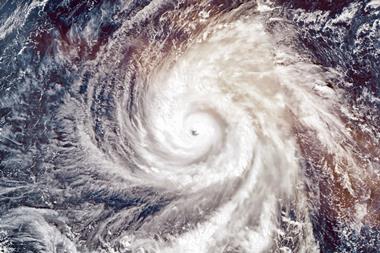
Territory: Caribbean
Region: Dominican Republic, Haiti, Puerto Rico
Date:10-17 December 2007
Event: Windstorm
Impact: Strong winds and up to 29cm of rain caused power losses, flooding and landslides in Puerto Rico, resulting in one death and leaving 80,000 without power and close to 150,000 without water. In Haiti, the storm caused two fatalities. The Dominican Republic bore the brunt of the storm, resulting from the most powerful winds and over 25cm of rain. Thirty-five people were killed, and properties in several towns were flooded by a 20m high wave of floodwater, released deliberately to prevent the Tavera Dam on the Yaque del Norte River from breaking. More than 7,500 homes were damaged in total, and 50,000 people displaced. Economic losses are estimated at $45 million.
Summary: Tropical Storm Olga originated in early December immediately east of the Lesser Antilles in the eastern Caribbean. Olga was designated a sub-tropical storm on 11 December, 85km east of San Juan, Puerto Rico. After heading west across Puerto Rico, the storm made landfall later the same day at Punta Cana in the Dominican Republic. Olga was reclassified as a tropical storm while over land, and then weakened as it crossed the island of Hispaniola and headed south into the Caribbean Sea. Thereafter, Olga weakened further to a tropical depression late on 12 December, while located 130km northwest of Kingston, Jamaica. Having touched Mexico’s Yucatan Peninsula, the depression turned eastwards, and strengthened to a tropical storm once again before reaching Florida. Here, it was absorbed by a cold front that subsequently drove a powerful winter storm across the eastern United States and Canada, taking 25 lives.
Data sources: ReliefWeb
wwww.reliefweb.int
Reuters AlertNet
www.alertnet.org
Additional sources: Wikipedia
http://en.wikipedia.org
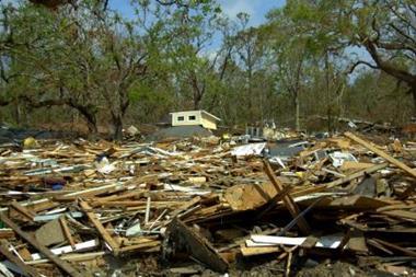
Territory: United States
Region: Tennessee, Arkansas, Kentucky, Alabama
Date: 5-6 February 2008
Event: Tornadoes
Impact: The tornadoes resulted in 59 fatalities and hundreds of injuries, making the outbreak the deadliest in the country since 1985, and in Tennessee and Kentucky since 1974. Worst affected was the state of Tennessee, with Jackson City and the Memphis and Nashville Metropolitan areas all badly hit. Memphis airport suffered roof damage. Sumner and Macon counties together accounted for 21 deaths, and sustained considerable damage, in the latter case as a consequence of the explosion of a gas pumping station. A federal disaster declaration was made for 11 counties in Arkansas and five in Tennessee. Initial estimates of insured losses are in excess of $40 million.
Summary: A succession of powerful winter storms across the southern United States, triggered the formation of more than 82 confirmed tornadoes, with 135 reported in total. Storm strength was typically two or less on the Fujita Scale, but five F3 and five F4 storms were also confirmed. The storm systems that spawned the tornadoes also generated giant hail and powerful straight-line winds, as well as heavy snowfall across much of the eastern United States.
Data sources:
UK Met Office
www.metoffice.gov.uk
Business Insurance
www.businessinsurance.com
Additional sources: Wikipedia
http://en.wikipedia.org
Territory: China
Region: Central, eastern and southern provinces: Hubei, Hunan, Zhejiang, Guizhou, Guangdong, Jiangxi, Guangxi, Fujian, Henan, Shandong, Jiangsu, Anhui, Shanghai, Chongtqing, Shanxi, Sichuan
Date: Mid-January to mid-February
2008
Event: Cold wave and snow storms
Impact: The snow storms and low temperatures have taken at least 107 lives and affected more than 100 million people, with over 1 million displaced. By the middle of February, the weight of accumulating snow had caused the collapse of an estimated 223,000 buildings, and damaged more than 850,000 others. The snow storms also resulted in massive damage to China’s forestry industry, especially in the south of the country, with monetary losses estimated at $8 billion. In all, around 10% of the country’s forests have been destroyed. Transport infrastructure was also badly affected, with hundreds of thousands stranded for days at railway stations and airports, More than 24 million hectares of farmland were damaged. Power losses affected tens of millions of homes across the country, and over 1.5 million livestock were lost. As of mid-February, economic losses for the cold wave were estimated to be somewhere between $3 billion and $15 billion.
Summary: The severe winter weather started on 10 January, when a mass of freezing air settled across the country and sent blizzards raging across central, eastern and southern provinces, in some cases affecting areas where winters are normally mild, and bringing snow to places where it is largely unknown. Temperatures fell as low as minus -320C, and in places stayed below -250C for 10 days or more. In many places, the snowfall was the worst for 50 years, and the winter is the coldest across the country since 1986-7. Some blame the severe weather on the prevailing La Niña conditions in the Pacific.
Data sources: Wikipedia
http://en.wikipedia.org/wiki/2008_Chinese_winter_storms
CNN
www.cnn.com
Additional sources: Business Insurance
http://businessinsure.about.com
Territory: United States, Canada
Region: Mid-West, SE and NE states, Canadian Maritime provinces
Date: 8-18 December 2007
Event: Winter storm
Impact: In total, the storms claimed at least 64 lives across nine US states and three Canadian provinces. Power cuts affected more than 1.5 million people, including 600,000 in Oklahoma (40% of the state’s population), and 20,000 in eastern Canada. Thousands of flights were cancelled, from Chicago, Tulsa, Kansas City and Newark, New York, and Boston airports, among others. Locally strong winds caused damage to power lines and roofs across Pennsylvania, Massachusetts and Rhode Island, and winds over 100kmh affected much of eastern Canada.
Summary: During December 2007, three powerful and disruptive winter storms affected many parts of the central and eastern United States and eastern Canada. An ice storm struck the Mid-West and Great Plains from 8 – 11 December, bringing freezing rain, snow and thunderstorms. On 13 December, a second storm brought heavy snow across New York and New England, and from 15 – 16 December, a third. This was a major winter storm system that stretched from Kansas to the Canadian Maritime provinces, and which dumped record amounts of snow on Ontario and freezing rain across the Appalachian Mountains, and spawned tornadoes across the southeastern states. Up to 50cm of snow fell in Quebec and across New England, with ice accumulations as thick as 3.8cm in Kansas and Missouri. Boston’s snowfall exceeded that for the whole of the 2006-7 winter.
Data sources: Met Office
www.metoffice.gov.uk
NOAA
www.ncdc.noaa.gov
Additional sources:
Wikipedia
http://en.wikipedia.org
Also on NOAA’s site at:
www.ncdc.noaa.gov


No comments yet