


A repeat of the 1868 Hayward fault California earthquake today would have enormous consequences. Property worth more than $500 billion and approximately 5 million people in six surrounding counties would suffer badly from such a quake. By Thomas Brocher and other members of the 1868 Hayward Earthquake Alliance
A potentially catastrophic earthquake in the heart of the San Francisco Bay area is increasing likely. Geologic studies along the southern Hayward Fault in the East Bay indicate that this fault has generated 12 major earthquakes in the last 1900 years, most recently in 1868. These earthquakes were powerful enough to offset the ground surface, indicating that they had magnitudes greater than 6.3. The average interval between these earthquakes is 160 ± 65 years (one standard deviation uncertainties) based on radiocarbon dating of the soils they disturbed. The last five earthquakes seem to have occurred more frequently, however. They are separated by an average interval of only 140 ± 60 years, as James Lienkaemper of the US Geological Survey (USGS) and others have written in an article to be published shortly.
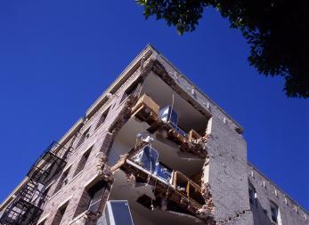
This year marks the 140th anniversary of the Magnitude 6.8 earthquake which broke a section of the Hayward Fault from the location of present-day Fremont to probably just north of Oakland on 21 October 1868. Known until 1906 as “the great San Francisco earthquake” for the damage it caused to the major population centre of the time, the 1868 earthquake resulted in the strongest shaking the whole Bay Area had experienced since its settlement by Europeans. Unreinforced masonry walls came down in San Francisco, Oakland and San Jose, a report published by the Carnegie Institute following the 1906 San Francisco earthquake recounts. Huge societal exposures to the next 1868 earthquake
Along most of its length, the Hayward Fault runs through Alameda County where the cities of Berkeley, Oakland, Alameda, Hayward and Fremont lie either on or directly adjacent to the fault’s trace. A repeat of the 1868 earthquake today would have enormous consequences. It would affect property worth more than $500 billion and approximately 5 million people in six surrounding counties. The population today is more than 19 times what it was in 1868.
According to a 2008 report for the US Department of Labor’s Bureau of Labor Statistics, the exposure of employers, employees and wages to an earthquake along the Hayward Fault ($25 billion in quarterly wages) greatly exceeds those that were at risk to Hurricane Katrina ($3 billion to $4.7 billion) in 2005. Approximately 87,000 employers supporting 1.5 million jobs are located in areas where very strong shaking is expected.
The report stated that that the industries most affected would include health care and social assistance, educational services (including the largest employer in the East Bay, University of California Berkeley with its 20,000 employees and 30,000 students), as well as manufacturing and the retail trade. Older commercial districts with vulnerable buildings are expected to be closed for months. Severe effects of a repeat of the 1868 earthquake
Preliminary estimates by catastrophe modeler Risk Management Solutions (RMS) of total residential and commercial economic losses, including damage to private buildings and contents, business interruption and additional living expenses, due to shaking alone exceed $120 billion for a repeat of an 1868 earthquake.
Damage to infrastructure, the effects of fires following the earthquake and post-event amplification, such as economic demand surge, claims inflation, repair cost delay inflation and coverage expansion, may substantially increase the loss total. Predicted losses will be concentrated (>95%) in five Bay Area counties: Alameda, Santa Clara, San Francisco, Contra Costa and San Mateo. Alameda and Santa Clara counties account for more than 75% of the forecast insured residential loss and slightly less than 70% of the insured commercial loss. Few homeowners or businesses buy earthquake insurance. Presently more than 90% of residential losses and around 85-90% of commercial losses will be uninsured, although loss amplification and post-event fires can impact this.
The primary drivers of Bay Area economy, white collar jobs and tourism, are likely to suffer severely. Studies conducted by the Association of Bay Area Governments (ABAG) and published in 2003 indicate that land, sea and air transportation networks will all be strongly disrupted and probably temporarily shut down. Interstate 580, one of two major east-west arteries into the Bay Area, could be offset horizontally as much as 1.8m (6 feet).
Seismically robust bridges and tunnels are currently replacing or upgrading major transportation links between Oakland and San Francisco, including the Bay Bridge and the BART tunnel beneath the bay. Until this construction is completed several years from now, however, it is likely that the more than 180,000 daily commuters using these transportation links will have to seek overtaxed alternate routes for months.
The Oakland and San Francisco international airports and nearly all the region’s port facilities are built on landfill over very young and soft materials strongly susceptible to damage by liquefaction and strong shaking, a scenario study on a Magnitude 7.0 earthquake, published in 1996 by the Earthquake Engineering Research Institute (EERI), found. As a result, the capacity to deliver the goods needed to support recovery will be significantly diminished.
Disruption will not be limited to only major transportation routes. In 2003, ABAG estimated that a repeat of the 1868 earthquake could result in approximately 1,100 road closures, including 900 in Alameda County alone. Expected common causes of these short term closures are damage to bridge abutments, surface cracking and offset by the fault displacement in the quake, land slides in the hills, liquefaction in areas of landfill, and extensive collapse or leaning of major buildings into roads.
Water delivery to much of the region will be interrupted. In 2002, the Bay Area Economic Forum reported around $17 billion of potential economic losses due to the rupture of the Hetch Hetchy aqueduct, which crosses the southern Hayward Fault and provides water for more than 2.4 million Bay Area residents. More than half of the losses would be to commercial and industrial facilities that depend on this water.
The forum attributed roughly 30% of the projected loss to the lack of adequate water supply to suppress post-quake fires. East Bay water customers may fare better. The East Bay Municipal Utility District conducted major seismic retrofits and upgrades after the 1989 Loma Prieta earthquake. The San Francisco Public Utilities Commission, which operates the Hetchy Hetchy dam and aqueduct system, is in the process of seismically retrofitting this 70 year old water delivery system.
Ominous comparisons
The fault that ruptured in the Magnitude 6.9 Kobe, Japan, earthquake in 1995 is a close analogue to the Hayward Fault. The geography of Kobe, a port city built along the Nojima Fault on Osaka Bay, is strikingly similar to the East Bay, with a large population living on the plains between the mountains and the shore. The Nojima Fault, like the Hayward Fault, is a strikeslip fault, and it has a similar length.
The 1995 Kobe earthquake caused more than 5,000 fatalities and widespread damage to buildings and infrastructure. Fire was a major contributor to the death toll. Ground failure, especially liquefaction, damaged the port facilities in Kobe, resulting in a permanent loss of business as shipping companies permanently relocated to undamaged ports in Japan. Large segments of Kobe and nearby communities previously populated by low income residents have not yet been rebuilt. In general, residences and commercial buildings built in Japan before 1995 were not as resilient as those constructed in the last 30 to 40 years in the San Francisco Bay area, and the Kobe area may not have been as prepared for earthquakes as the Bay Area is today. Nonetheless, a 1996 ABAG study suggested that a repeat of the 1868 earthquake would result in about 90,000 uninhabitable units, displacing approximately 220,000 residents and resulting in 60,000 to 70,000 of them seeking temporary public shelter.
Two-thirds of this impact is forecast to occur in Alameda County where 62% of the population is ethnic or minority, according to the 2005 Communities Survey by the US Census Bureau. Census data from 2000 indicates that 27% speak a first language other than English, and 11% of the country’s population have incomes below the poverty line. These residents tend to work and reside in relatively old buildings predating modern building codes.
Hurricane Katrina demonstrated the profound impact on the local economy when large numbers of residents are displaced from their homes. In the San Francisco Bay area those displaced residents are also likely to speak a myriad of foreign languages. Dealing with this displacement, as well as the physical damage and disruption, is likely to take years.
Pay now or pay later?
According to estimates from USGS, San Francisco Bay Area businesses and governments have invested or are committed to invest more than $30 billion in strengthening important infrastructure since the 1989 Loma Prieta earthquake. Residents have repeatedly supported bond measures to cover the costs of retrofitting key lifelines. The California Department of Transportation (Caltrans) has invested at least $10 billion in retrofitting and replacing toll bridges in the Bay Area, as well as all the elevated sections of state owned roads.
As a result of the 1994 California State Senate Bill 1953, hospitals throughout the Bay Area are being seismically strengthened or replaced, although the deadline for such work has now been postponed until 2030. Since 1989, the Pacific Gas & Electric Company has invested over $2 billion to replace old cast iron gas pipes with flexible plastic pipes in liquefiable regions, and strengthened key elements of its electrical transmission and distribution network. The BART District is retrofitting its tunnel beneath San Francisco Bay and its elevated tracks. Many cities have replaced or seismically strengthened vulnerable city halls and emergency response centres.
The relatively low rate of earthquake insurance coverage in both the residential and commercial markets is troubling. In contrast to Hurricane Katrina where insured losses were between about 33% and 50% of total economic losses, according to RMS, only about 10% of the total projected Hayward Fault earthquake losses will be covered by insurance.
Major strides have been made since 1989 in improving the resilience of the San Francisco Bay area to earthquakes. Still, a large Hayward Fault earthquake is likely to be a super catastrophe that would dramatically change East Bay communities for decades.
As the 1868 Hayward Earthquake Alliance, we are exploring the extent and ramifications of such a catastrophe by investigating questions such as: (1) What is the potential for cascading failures of utilities and transportation systems that depend on each other in recovery? (2) How will the large number of predominantly residential-use multi-story buildings weakened at ground floor by large numbers of openings for garages or windows perform? (3) What will be the long term postearthquake economic climate and will businesses leave the area?
We intend that our results will be directly applicable in proactive decision making by community leaders. To help raise awareness of these hazards, the 1868 Hayward Earthquake Alliance, which is a private-public consortium, is planning many activities and events to commemorate the 140th anniversary (see www.1868alliance.org) including public forums, conferences, publications, websites, videos and public service announcements.
Postscript
The authors are members of the 1868 Hayward Earthquake Alliance.
Thomas Brocher, US Geological Survey, Menlo Park, brocher@usgs.gov
Keith Knudsen, California Geological Survey, keith_knudsen@urscorp.com
Mary Lou Zoback, Risk Management Solutions, marylou.zoback@rms.com
Jeanne Perkins, Association of Bay Area Governments, jeannep@abag.ca.gov Margaret Hellweg, University of California, Berkeley, peggy@seismo.berkeley.edu William Savage, US Geological Survey, Menlo Park, wusavage@usgs.gov
Kathy Bailey, California Governor’s Office of Emergency Services, kathleen_bailey@oes.ca.gov www.1868alliance.org
References:
ABAG, Southern Hayward Earthquake – 1,138
road closures, 2003, (http://quake.abag.ca.gov/eqtrans/hasm_rslt.html).
ABAG, Shaken Awake! Report Summary, 1996 (http://www.abag.ca.gov/bayarea/eqmaps/shelpop/summary.html).
Bay Area Economic Forum, 2002, Hetch Hetchy Water and the Bay Area Economy, located on line at: http://www.bayeconfor.org/pdf/hetchhetchyfinal2.pdf
Earthquake Engineering Research Institute, Scenario for a magnitude 7.0 earthquake on the Hayward Fault, HF-96, 1996 (http://haywardfault.eeri.org/index.php).
Holden, R. J., D. Bahls, and C. Real, Estimating economic losses in the Bay Area from a magnitude-.69 earthquake,
Bureau of Labor Statistics, Monthly Labor Review, Vol. 130, No. 2, Jan. 10, 2008 (http://www.bls.gov/opub/mlr/2007/12/art2abs.htm). Lawson Report on the California Earthquake of April 18, 1906, Carnegie Institution of Washington, Pub. 87, Vol. 1, 1908.
Lienkaemper, J., P. Williams, and T. P. Guilderson, New evidence for 12 Southern Hayward Fault earthquakes in past 1900 years, Seismological Res. Lett., vol. 79, in press, [abstract], 2008.


No comments yet