


By Professor Bill McGuire of Benfield - UCL Hazard Research Centre
Flood events, either associated with unusually heavy seasonal rains or with tropical cyclones, have dominated the period of this bulletin. In West, Central and East Africa, 22 countries experienced the heaviest seasonal rains for 35 years. In the Caribbean and Central America, Mexico, Nicaragua, Costa Rica, Haiti and the Dominican Republic all suffered badly, while further south, Colombia has been experiencing serious flooding since the end of June. Mexico was particularly badly hit with flood losses likely to top $1 billion.
Much of the flooding in the Caribbean and Central America was associated with Atlantic hurricanes, most notably Dean, Felix and Noel. Of these, Dean was by far the most destructive, leading to losses of $3.8 billion, with estimates of insured losses put at somewhere between $1.5 and 3 billion. In Asia, Cyclone Sidr had a devastating impact on Bangladesh, affecting 27 million people, taking more than 3,000 lives, and causing damage estimated at around $0.5 billion.
Geological activity over the period was moderate, with lethal earthquakes striking Peru and Indonesia, and increased activity of the Indonesian volcano, Kelud, requiring evacuation of the surrounding area. The Peruvian event was the most serious, resulting in the loss of 519 lives and the destruction of 58,000 homes.
In California, wildfires were again a problem this autumn, burning over 2,000 km2 (500,000 acres), destroying at least 1,500 homes, and leading to insured losses of at least $1.6 billion.
Territory: Caribbean and Central America
Region: Windward and Leeward Islands, Puerto Rico, Dominican Republic, Haiti, Jamaica, Cayman Islands, Mexico, Belize, Honduras, Nicaragua
Date: 13 - 23 August
Event: Hurricane Dean
Impact: Dean was responsible for 41 deaths, mostly in the Dominican Republic, Haiti and Mexico. In St. Lucia, Martinique and Dominica, hundreds of buildings were destroyed, and banana and sugar cane crops were severely damaged, with a major impact on the island economies. Total losses in Martinique are estimated to be at least $200 million. In Haiti, 10,000 homes were destroyed or damaged. With the storm passing just 80 km to the south as a Category 5 storm, Jamaica also suffered badly, with 300,000 people affected, buildings damaged and destroyed, power out, and roads blocked by floods and landslides. In Mexico, the worst damage was sustained by Chetumal, the state capital of Quintana Roo, where a major storm surge and winds up to 270kmh caused serious flooding and building damage. The storm also shut down Mexico's oil production for a time. The total bill for the storm is estimated at $3.8 billion, with insured losses between $1.5 and 3 billion. Insured losses in Mexico alone may be as high as $400 million.
Summary: Hurricane Dean was the most intense tropical cyclone in the Atlantic Basin since Wilma in 2005, the ninth most intense Atlantic hurricane ever recorded, and the third most intense at landfall. Dean was the first Atlantic hurricane to make landfall at Category 5 intensity since Hurricane Andrew in 1992. The storm developed from a tropical depression 835km WSW of Cape Verde, and on 14 August intensified to a tropical storm as it headed rapidly westwards. The storm was upgraded to Hurricane Dean on 15 August, and crossed the Lesser Antilles as a Category 2 storm on 17 August. Dean strengthened to Category 3 and then 4, but weakened slightly as it skirted south of Jamaica on 19 August. The following day, Dean made landfall as a Category 5 storm 65km north of the border between Mexico and Belize. Having weakened during its crossing of the Yucatan Peninsula, Dean strengthened to Category 1 and then 2, making a second landfall in Mexico, south of Tuxpan, on 22 August. Thereafter, the storm largely disintegrated over central Mexico.
Data sources: ReliefWeb www.reliefweb.int
Reuters AlertNet www.alertnet.org
Additional sources: Insurance Journal www.insurancejournal.com
UNICEF www.unicef.org
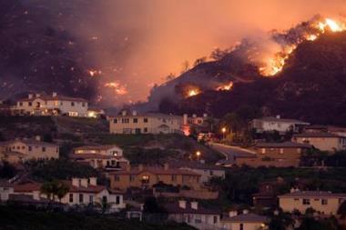
Territory: United States
Region: California
Date: 20 October to 9 November
Event: Wildfire
Impact: In total, the fires burned over 2,000 km2 (500,000 acres) across a swathe of southern California from Santa Barbara County to the Mexican border. At least 1,500 homes and 1,300 other structures were destroyed, along with several hundred vehicles. Nine people are known to have died as a direct result of the fires, with close to 130 injured, including around 100 fire fighters. Most of the damage, loss of life and injuries occurred in San Diego County. In total, more than 900,000 people were evacuated, the largest evacuation event in California's history. Damage to power lines resulted in several outages, leading to more than 25,000 people losing supply. The cost of the fires is estimated at up to $1.6 billion (insured), with San Diego's Witch Creek fire alone accounting for close to $1 billion.
Summary: The state of California has a history of wildfires, which have become increasingly problematical in recent decades. As with previous events, such as the Oakland fires of 1991, the fires were driven by unusually strong Santa Ana winds, gusting to 140kmh. They followed a hot, dry summer with record drought conditions in southern California; Los Angeles experienced its driest year on record, receiving just 82mm of rain. The fires appear to have had a number of sources, including arson and a vehicle accident. Several resulted from high winds bringing down power lines; other causes are still under investigation. The two largest fires - Witch Creek and Harris - occurred in San Diego County, and both broke the record for the biggest fires in Californian history. Other major fires developed in the counties of Los Angeles, Ventura, Orange, San Bernardino, Santa Barbara and Riverside. Major fires also caused problems in the adjacent Mexican state of Baja California.
Data sources: Environmental Finance www.environmental-finance.com
Office of the Governor of California www.calfires.com
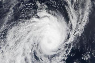
Territory: Caribbean, United States, Canada
Region: Bahamas, Cuba, Dominican Republic, Haiti, Jamaica, Puerto Rico, Massachusetts, Maine, Rhode Island; Newfoundland, Nova Scotia, New Brunswick, Prince Edward Island
Date: 27 October to 2 November 2007
Event: Hurricane Noel
Impact: Noel brought torrential (up to 55cm) rain to the Dominican Republic, causing extensive flooding in low lying areas. More than 16,000 houses were damaged or destroyed and over 70% of the coffee crop ruined, at an estimated cost of $77 million. The death toll in the country is estimated at 87. In Haiti, 400 homes were destroyed and a further 57 lives lost.
In Cuba, up to 36cm of rain caused extensive flooding, leading to the destruction of more than 1,000 homes.
A small number of fatalities were also reported in Jamaica, Puerto Rico and the Bahamas, bringing the total for the storm up to 151. In
New England, hurricane force winds brought down power lines so that 80,000 people in Massachusetts lost their supply. In Canada, 150,000 people in New Brunswick and Nova
Scotia had no power for several days. Local damage occurred in Labrador, Nova Scotia and Quebec, as a result of strong winds (up to 137kmh), wave action, heavy rain (in excess of 11cm) and wet snow.
Summary: Noel was the 14th named storm of the 2007 Atlantic hurricane season. It was also the fifth, and most lethal, hurricane of the season. The storm formed, on 27 October, close to Puerto Rico and the Leeward Islands. Noel crossed Haiti as a tropical storm on 29 October and made landfall in southern Cuba the following day, with wind speeds of 95kmh. It crossed the Bahamas on 1 November, and strengthened to a
Category 1 hurricane the following day. Later the same day, Noel began the transition to an extra-tropical cyclone, but winds remained as high as 140kmh. The storm headed rapidly northeast, bringing strong winds and heavy rain to New England and the Atlantic Provinces of Canada. It continued to head northwards as an extra-tropical low pressure system, bringing tropical storm force winds to Greenland on 5 November before finally dissipating.
Data sources: NOAA www.nhc.noaa.gov/2001noel.html
NASA www.nasa.gov
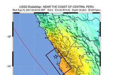
Territory: Peru
Region: Central Peru
Date: 15 August 2007
Event: Earthquake
Impact: Worst affected were the cities of Chincha Alta, Ica and Pisco, in the Ica region, and San Vincente de Cañete in the Lima region. Pisco bore the brunt of the damage, with around 80% of the city destroyed (~58,000 buildings) and up to 430 lives lost. Most of the buildings were constructed from unreinforced adobe (mud brick). The quake damaged a further 13,000 homes and more than 100 hospitals, with 14 hospitals completely destroyed. The final human toll, for the whole region affected, was 519 dead and 1,266 injured. Landslides and open fractures resulted in widespread problems with transport (including the Pan-American Highway) and communications, while power outages were common. At this stage, no cost estimates are available.
Summary: At 18.40 (local time) on 15 August, a Magnitude 8.0 earthquake struck off the coast of central Peru, around 150km SSE of the capital Lima, and 45km WNW of Chincha Alta, where some of the strongest shaking was felt. At just 30km, the quake was shallow enough to cause serious damage to property and large loss of life. On the Modified Mercalli Scale, the shaking intensity was VIII at Chincha Alta, VI at Lima, V at Cusco and IV at Arequipo. The quake was also felt as far afield as Bolivia, Colombia (intensity III shaking in Bogota), Chile and Brazil. It generated a small tsunami with wave heights reaching about one-third of a metre. There were at least a dozen powerful aftershocks, in excess of Magnitude 5, in the following hours. The quake occurred in an area of high seismicity at a subduction zone where the Nazca Plate, to the west, is being thrust beneath the South American Plate in the east. Major earthquakes occurred in the same area in 1942, 1974 and 1996.
Data sources: United States Geological Survey http://earthquake.usgs.gov
Reuters AlertNet www.alertnet.org
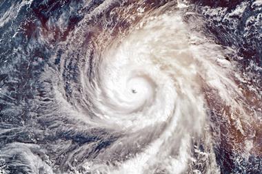
Territory: Bangladesh, India
Region: Districts of Bagerhat, Patuakhali, Barguna, Pirojpur, Barisal, Jhalkhati, Bhola, Mandaripur, Gopalgonj, Shariatpur, Khulna and Satkhira (Bangladesh); West Bengal, Tamil Nadu (India)
Date: 15 November 2007
Event: Cyclone Sidr
Impact: In total, more than 27 million people in 15 districts were affected by the storm and associated torrential rains. The reported death toll is more than 3,000 at the time of writing, but this is expected to rise further. The loss of life would have been far greater without the pre-event evacuation of around 3.2 million people. In 1970, a Category 3 storm killed 300,000 people, while another in 1991 took 138,000 lives. Patuakhali, Barguna and Jhalokati, with a combined population of 700,000, were inundated by a 5m storm surge, which damaged at least 20,000 houses. Crop damage across the affected region is severe and water supplies were also affected. A serious disruption of power supplies led to a 36 hour outage across nearly the whole country. The capital, Dhaka, was also seriously affected by strong winds and floods, which resulted in water and power supplies being disrupted. Total losses are currently estimated at around $0.5 billion.
Summary: Cyclone Sidr (also known as Very Severe Cyclonic Storm Sidr and cyclone 06B) developed from an area of disturbed weather in the Bay of Bengal, southeast of the Andaman Islands. A tropical cyclone alert was issued on 11 November as the system developed into a deep depression and headed northwestwards. The following day the weather system was upgraded to a cyclonic storm, and on 13 November to a very severe cyclonic storm. On 15 November, Sidr made landfall close to Cox's Bazaar as a Category 4-equivalent storm, with sustained wind speeds of 215kmh, weakening thereafter as it headed northwards towards Dhaka.
Data sources: Relief Web www.reliefweb.int
Reuters Alertnet www.alertnet.org
Territory: West, Central and East Africa
Region: Mali, Burkina Faso, Guinea, Mauritania, Niger, Côte d'Ivoire, Senegal, Gambia, Liberia, Nigeria, Côte d'Ivoire, Togo, Sierra Leone, Benin and Ghana, Sudan, Chad, Central African Republic, Cameroon, Eritrea, Ethiopia, Somalia, Kenya, Rwanda and Uganda
Date: July to November 2007
Event: Floods
Impact: Two million people have been affected, with 650,000 losing their homes and more than 200 losing their lives. In West Africa, 15 countries have experienced the worst floods for 35 years, with more than 800,000 people affected. Ghana has been worst hit, with more than a third of a million people affected, over 30,000 homes, 1,500 km of roads and thousands of hectares of crops destroyed. In neighbouring Togo, 18,000 homes were destroyed, in addition to 68 bridges and seven dams. Nine countries in Central and East Africa have experienced serious flooding, in particular the Sudan, where more than half a million people have been affected. In Uganda, and in particular the eastern part of the country, floods have impinged upon the lives of a further 300,000 people and inundated 8,500 acres of farmland. Here, tens of thousands of mud-brick homes have crumbled in the wet conditions. Ethiopia has also seen extensive flooding across regions including Amhara, Gambella, Afar, Tigray and Somali, that has affected 240,000 people, of which 74,000 have been displaced from their homes.
Summary: Massive and extensive flooding has affected 22 countries in Africa since July. Africa experiences two rainy (monsoon) seasons, the first in late spring or early summer, and the second later in the summer. It is this second monsoon that has brought continuous and heavy rains to much of western, central and eastern parts of the continent. In addition to the problem of immediate damage to property and infrastructure, there is also concern that extensive agricultural losses and water-logging of the land will result in food shortages and problems with planting the next crop.
Data sources: ReliefWeb www.reliefweb.int
Reuters AlertNet www.alertnet.org
Additional sources: UK Met Office www.metoffice.gov.uk
Territory: Mexico
Region: Tabasco and Chiapas states
Date: Late October - early November 2007
Event: Flood
Impact: The flooding - described the worst for 50 years - affected more than 1 million people, over half the population of Tabasco, and left 80% of the state under water. Eight hundred thousand people were displaced and 350,000 trapped in their homes. Many thousands required rescue. An estimated 700,000 homes were inundated, including 519 neighbourhoods in the capital, Villahermosa. Here, 90% of the population lost electricity supplies. In a situation reminiscent of New Orleans after Hurricane Katrina, more than 50% of the capital remained flooded 11 days after the start of the floods. The death toll is estimated at 24. Agriculture was very badly hit, with the entire cocoa crop (Tabasco produces 80% of the country's cocoa) lost, and the banana, bean and corn crops seriously affected. Storms associated with the rains forced the closure of three of Mexico's main oil ports, temporarily preventing nearly all oil exports and halting one-fifth of the country's oil production. In early November, the Mexican Association of Insurance Institutions estimated the economic cost of the floods to be around $700 million in Tabasco alone.
Summary: The long term flood risk in the southern Mexico state of Tabasco has been progressively increasing as a consequence of sea-level rise, subsidence due to hydrocarbon extraction, land erosion and deforestation, and dam construction. Torrential rains, beginning on 28 October, led to the local dams exceeding their critical storage capacities. The Grijalva, La Sierra, Carrizal and Puxcatan rivers burst their banks and broke through the protective system of dykes and levees. High ocean tides exacerbated the situation by causing the rivers to back up. Total rainfall amounted to 90cm in just four days; twice the previous record, with individual river flows estimated at up to 5,000 m3 per second. The low-lying nature of much of the state, including the capital (much of which is below sea level) means that, in many areas, the floodwaters had to be pumped out.
Data sources: Relief Web www.reliefweb.int
OCHA Situation Report 5: Tabasco and Chiapas Floods www.reliefweb.int


No comments yet