


A magnitude 8.6 earthquake off Sumatra triggers a tsunami warning but causes little damage yet

Catastrophe modeling firm AIR Worldwide issued the following incident assessment on the tsunami warning in the Indian Ocean.
On April 11 a magnitude 8.6 earthquake struck off the west coast of Northern Sumatra, approximately 434 km southwest of Banda Aceh, the closest population center.
According to the United States Geological Survey (USGS), the earthquake occurred at 2:38 PM local time (8:38:37 UTC) and struck at a depth of 22.9 kilometers. The main shock was followed by a series of moderate aftershocks until a little more than two hours later, when a M8.2 aftershock struck 618 km south-southwest of Banda Aceh, at 4:43PM local time (10:43:09 UTC) at a depth of 16.4 km.
Immediately after the main shock, the NOAA Pacific Tsunami Warning Center issued an Indian Ocean-wide tsunami watch for 28 countries. This tsunami watch was canceled, followed by a new warning after the aftershock, which also was canceled.
“Southeast Asia is one of the most complex, and fastest deforming, seismic zones in the world,” said Dr. Bingming Shen-Tu, senior principal scientist at AIR Worldwide. “Seismicity in the region mostly results from the interactions of two major tectonic plates: the Indo-Australia plate and the Eurasian (Sunda) plate, which are converging at rates of 5 to 7 cm per year.”
Thailand’s National Disaster Warning Center issued an evacuation order to residents in six provinces along the country’s west coast
“Today’s earthquakes occurred southwest of the mega-thrust earthquake ruptures in 2004 and 2005 along the Andaman –Sumatra subduction zone. Unlike the 2004 and 2005 earthquakes, which ruptured the subduction zone, this earthquake occurred within the Indo-Australia plate, which is moving north to northeastward and subducting under the Sunda plate (or Eurasia plate).
Scientists have generally considered Australia, Indian Ocean, and India as one single rigid plate. However, significant internal deformation has been noticed along, and in the vicinity of, the geologic structure called the Ninetyeast Ridge, which separates the Australia plate in the east from India plate to the west. The Ninetyeast Ridge itself has experienced many large earthquakes in the last century.”
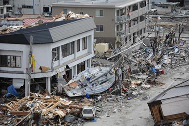
The USGS reported that the greatest shaking intensity experienced in Northern Sumatra was V-VI on the Modified Mercalli intensity scale (MMI)—which translates to very light to light damage. Indeed, no major damage has been reported in the affected area. As a precaution, people in Banda Aceh, Sumatra, evacuated offices, hotels and residences.
Thailand’s National Disaster Warning Center issued an evacuation order to residents in six provinces along the country’s west coast, including the popular tourist destinations of Phuket, Krabi, and Phang-Nga.
Further afield, buildings were evacuated in Dhaka, Bangladesh. In Kolkata, in the Indian state of West Bengal, there are reports that some buildings developed cracks.
According to AIR, buildings in the affected region often have an irregular floor shape. In mid- to high-rise buildings, asymmetrical torsion rigidity has led to heavy damage during earthquakes. Poor detailing and workmanship, inadequate materials, and a lack of rigorous inspection and quality control procedures for building construction are the major factors that exacerbate building damageability.
Due to the location of these earthquakes, AIR does not expect significant insured losses from this event. AIR is continuing to monitor the situation.


No comments yet