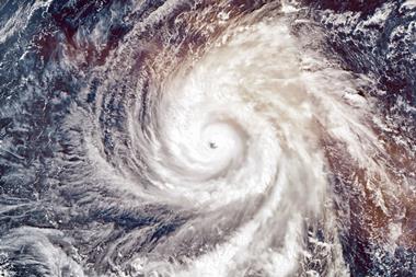


During the 2008 hurricane season, the number of tropical storms and hurricanes exceeded long term averages. The year produced two events which resulted in serious damage in the United States; Hurricanes Gustav and Ike, and an unusually strong late storm, Hurricane Paloma. By Peter Dailey
What does one expect in the “typical season?” What influenced this year’s activity, and how does it compare to the last several seasons?
By the end of October, the 2008 hurricane season had produced two very notable storms: Hurricanes Gustav and Ike. Both achieved Category 4 status during their life cycles and both wreaked havoc in the Caribbean. While Ike’s intensity at landfall was comparable to Gustav (both estimated to have produced sustained winds at landfall of 110mph or 177kph by the National Hurricane Center), it was a much larger storm with a larger radius of hurricane force winds. In addition, the Texas coastal exposure directly subjected to storm surge from Ike was more concentrated than along the coast of Louisiana where Gustav made landfall, despite Louisiana’s generally lower elevation.
In November Hurricane Paloma became the eighth hurricane of the 2008 Atlantic season. Paloma was the second most powerful hurricane recorded in the month of November since Hurricane Lenny in 1999.
Atlantic tropical cyclone climatology
Figure 1 shows how one would expect the typical Atlantic hurricane season to evolve. Tropical storms—tropical cyclones that achieve a wind intensity of 39mph —typically begin to form in the months of May and June, with the first expected by the end of June. Activity accelerates in the most active months of August and September, and then tails off by the season’s official end in November. By the end of a typical season, one expects about 11 named tropical storms will have formed.
As Figure 1 also illustrates, hurricane formation follows a similar pattern over time, with activity levels peaking in early September. About 58% of tropical storms achieve hurricane status, with winds of at least 74mph, leading to about six hurricanes by the end of the typical season. About 45% of hurricanes reach major hurricane status—Category 3 or higher on the Saffir-Simpson scale, with winds exceeding 110mph. About three major hurricanes will have developed by the end of a typical Atlantic season.
Hurricane Bertha achieved major hurricane status early on in the season, but the storm remained over the open Atlantic throughout its life cycle and did not affect land interests. Gustav achieved Category 4 status just before crossing the west coast of Cuba, but only maintained that strength for about 12 hours, ultimately arriving on the coast of Louisiana as a strong Category 2 hurricane. Hurricane Ike achieved Category 4 status as well, causing significant damage in the already hurricane-worn Caribbean, but was unable to re-intensify to major hurricane status after being subjected to the mountainous terrain of Cuba.
Of the other five hurricanes, Dolly made landfall as a marginal Category 2 just north of the border with Mexico, causing low level damage centered near Brownsville, Texas. Hanna achieved Category 1 status for less than a day and made landfall near the border between South and North Carolina as a strong tropical storm. Hurricane Kyle raced past northern New England to make landfall near Yarmouth, Nova Scotia as a Category 1 hurricane.
Omar reached major hurricane status, Category 3, as it approached the Virgin and Northern Leeward Islands. However, Omar threaded the needle through the Anegada Passage; its closest pass to land was about 25 miles to the east of St. Croix and about 55 miles (89km) to the northwest of St. Martin and it quickly weakened as it moved very rapidly away from the Northern Leeward Islands. In Omar’s passage through the islands, hurricane force winds extended outward in a compact swath just 35 miles from the storm’s center.
Hurricane Paloma, which also reached major hurricane status, crossed the Cayman Islands as a Category 4 hurricane with 145 mph winds. The hardest-hit of the islands was Cayman Brac, which was the only one of the Caymans to receive a direct hit from Paloma. Hurricane Paloma then made landfall near Santa Cruz del Sur, Cuba, as a Category 3 hurricane. After leaving Cuba, it rapidly weakened, going from a Category 4 hurricane to a tropical depression in less than a day.
As of 1 December 2008, there had been 16 tropical storms, eight of which reached hurricane status. Among the hurricanes, there were one Category 1, two each of Category 2 and Category 3, and three Category 4 hurricanes. Three—Dolly, Gustav, and Ike—made US landfall at hurricane strength. By comparison, in an average season, one would expect 11 tropical storms, six hurricanes and three major hurricanes with one or two US landfalls. Thus, the counts in 2008 were above average.
The end of the 2008 Atlantic hurricane season
To put the season in perspective, Figure 3 shows the progression of tropical storm and hurricane count as of 1 December 2008. Note that the season started early with Tropical Storm Arthur, which was named on 31 May just before the official start of the season. Arthur was a short lived storm, only marginally meeting the requirements for a named system; it formed from the remnants of a tropical cyclone from Mexico’s Pacific coast and a pre-existing tropical wave. It is questionable whether a storm like Arthur would have been named decades ago.
Taking this into consideration, by the end of October, the 2008 season was already above average in terms of overall activity, and more typical in terms of how storms are intensifying—with roughly half of the named systems reaching hurricane strength and again about half of them reaching major hurricane status. The Atlantic hurricane season ended about two above average on both hurricane and major hurricane counts.
Forecasting
The main source of energy for hurricanes is the heat and moisture of the ocean surface, so one of the key factors that forecasters scrutinise is the projected sea surface conditions for the remaining months of a hurricane season.
The Atlantic sea surface temperature (SST) anomalies forecast by the International Research Institute for Climate and Society (IRI) at Columbia University is one of several operational ocean forecast models in operation and provides a good indication of how the ocean conditions are likely to develop through the remainder of a season. For the months of October through December 2008, it indicated that much of the tropical Atlantic would be within a quarter degree Celsius of average, though a large expanse of ocean might be significantly warmer than average.
Because many tropical cyclones form over the middle and far eastern part of the Atlantic in the second half of the season, there is the potential for such storms to be fuelled by warmer than average SSTs, as indicated by the forecast. However, the month of November typically does not produce hurricanes over the eastern Atlantic and equatorial latitudes where the IRI forecast indicated most of the anomalous warmth would occur within the tropics.
Another indicator of activity is the level of Atlantic wind shear, which describes the difference between surface and upper-level winds. Wind shear, which prevents tropical cyclones from reaching their full potential, is correlated with the SST anomaly pattern over the eastern Pacific known as ENSO. In the La Niña phase of ENSO, wind shear in the Atlantic is reduced, thereby leading to elevated levels of activity.
For the September to November timeframe, the IRI team had increased the estimated probability of an El Niño event, if a weak one. Even if an El Niño event begins, it is unlikely to have a major impact on the seasonal statistics, since the month of November typically encompasses less than 10% of the entire season’s activity.
How many of the hurricanes that form late in a year will make landfall along the North American coastline relates mainly to the steering currents in place at the time the storms are tracking. It is well known that storm movement is largely a reflection of the large scale atmospheric winds that change weekly or even daily. Thus, steering is a function more of “weather” than of “climate”, and short term changes in the atmospheric circulation can make a significant difference in the propensity of storms to reach the coastline.
Updates to 2008 Atlantic hurricane seasonal forecasts
What did the seasonal forecasters say about the end of the 2008 season? Several organisations updated their early season projections. In general, the view was pessimistic; virtually all revised their predictions upward. Part of the explanation for these adjustments was the warmer than average SST conditions forecast by groups like IRI Columbia combined with the expectation that the ENSO cycle would not counteract the effect of a warm ocean with higher than average shear conditions.
The number of tropical storms and hurricanes this year fell well within the range of seasonal predictions, with some forecasters faring better than others.
The 2008 Atlantic hurricane season was more active than normal, with more tropical storms, hurricanes, major hurricanes and US hurricane landfalls than expected in the typical year. This elevated level of activity is in line with what most seasonal forecasters projected, given their expectation for warmer than average ocean temperatures, among other key climate predictors.
Postscript
Peter Dailey is director of atmospheric science at AIR Worldwide. pdailey@air-worldwide.com. www.air-worldwide.com